This page under contruction
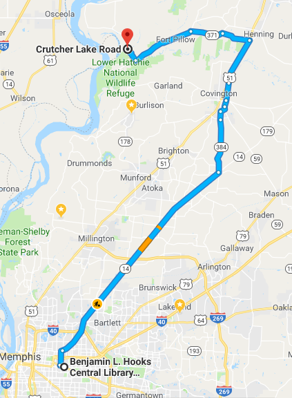
Location
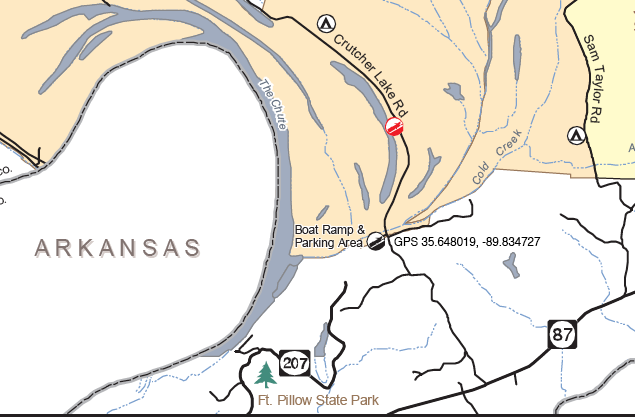
Crutcher Lake Rd. Ripley, TN where it crosses Cold Creek.
1 hour 24 minutes (60.9 miles)
GPS Coordinates: 35.648341, -89.834591
Follow signs for Fort Pillow State Park and the Great River Road until the sign indicating 2.5 miles to Fort Pillow. At that point, turn right onto Crutcher Lake Rd, continuing on the Great River Road and cross the bridge in slightly more than a mile arriving at sign on the left for the Anderson-Tully State Wildlife Management Area.
This is an oxbow lake formerly part of the Mississippi River. The Arkansas - Tennesee border runs down the middle of the chute. Additional details are here and here.
Minimum River Levels for safe paddling
Unknown at this point
Put-Ins, Take Outs
There is a large parking lot and a concrete boat ramp next to the bridge. There are also some low banks in the parking lot.


Places to Camp in the area
The campground at Fort PIllow has 30 sites, six of which will accommodate RV and camper trailers with 20/30/50 amp service. Fifteen sites have 20 amp service and water station in close proximity to each site. Primitive campers have their choice of nine different sites without electricity, but all have water in close proximity to each site. Each campsite has a grill/campfire pad, picnic table, lantern holder and pea gravel for tent set- up.
Services Available Along the River
None likely although there is a group of cabins across cold creek from the launch area
Highlights Along the River
None known at this point. An exploratory paddle is needed.
Potential Danger Spots Along the River
None known at this point. However, no current was observed at the launch site.
Places to eat
None identified as yet.
Other things to do
Hiking and fishing. More information here.
Medical Facilities
None known